
1 Watershed 1 Plan (1W1P)
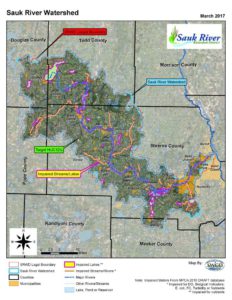
Sauk River Watershed
The Sauk River Watershed (070102020) lies in the heart of rural central Minnesota, encompassing a complex system of integrated lakes and streams. Located in the North Central Hardwoods Ecoregion, the Sauk River watershed transitions from an agricultural, semi-forested landscape in the northern region to a highly concentrated agricultural landscape in the central region to a very urbanized area in the southern region.
The Sauk River Watershed covers a large land area, over 1,042 square miles. The Sauk River originates from Osakis Lake, near the city of Osakis and flows southeasterly 134.9 river miles (MNDNR, 2011) to the city of St. Cloud, where it joins the Mississippi River. The watershed, like the Sauk River, extends in a northwest to southeast direction (see map below).
For policy documents and committee information please visit the Sauk River Watershed District’s website at http://www.srwdmn.org/.
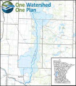
Pomme de Terre Watershed
The Pomme de Terre River Comprehensive Watershed Plan was the first one completed in Douglas County. The Pomme de Terre watershed covers a small portion of Douglas County, the north west corner containing Lake Christina, and most of Lund township. All the water in the Pomme de Terre watershed runs south to the Minnesota River. The Pomme de Terre is managed by a Joint Powers Board (JPB) that consists of SWCD board supervisors and county commissioners from each county that the watershed touches. The Pomme de Terre Comprehensive Watershed Management Plan and related documents can be accessed at https://www.pdtriver.org/projects/one-watershed-one-plan/.
Chippewa River Watershed
The Chippewa River Comprehensive Watershed Plan has been developed and submitted to the state for final review and approval. The draft plan, appendices, and public comments can be found at the link below. The Chippewa River Watershed begins in Otter Tail County and flows south to the Minnesota River. The website that is to house the planning documents is currently under construction, if you have any questions about the planning effort please contact our office.
Chippewa River Watershed Comprehensive Plan
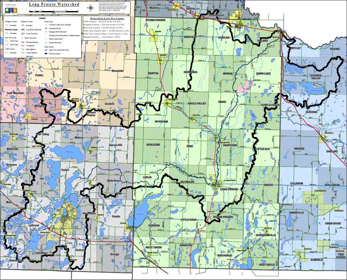
Long Prairie Watershed
The Long Prairie River Comprehensive Watershed Plan has been completed. Projects in priority areas of the watershed will start being funded in summer of 2023. The Long Prairie River encompasses the Alexandria Chain of Lakes and flows east to the City of Long Prairie then north to Motley where it pours into the Crow Wing River. Planning information and the final Comprehensive Watershed Plan can be accessed at https://www.co.todd.mn.us/1w1p/#1w1p-additional-info (expand the “Additional Information” tab to locate the plan documents).
Long Prairie One Watershed One Plan Project Website. Click here!
Long Prairie One Watershed One Plan Story Map: Click Here!
Long Prairie River Watershed Newsletter:
Volume 1- May 2021
Volume 2 – July 2021
Check out these awesome articles to help give you a better understanding of what a watershed is, and the process of 1W1P.
Part 1 – What Watershed are you?
Part 2 – Introducing the Long Prairie Watershed.
Part 3 -Rural Dictionary – Acronym of the Year.
Part 4 – Planning for a plan_The Long Prairie Watershed.
The Long Prairie River One Watershed One Plan Collaborative between Douglas, Morrison, Otter Tail, Todd and Wadena Counties and respective SWCD Boards invites the public to participate in a 60 day formal comment period on the Draft Long Prairie River Comprehensive Watershed Management Plan. A formal review period was initiated by the Policy Committee on May 20, 2022 and will be open until July 19, 2022. To review the plan, please visit the following web links.
Draft Plan Summary:
https://www.co.todd.mn.us/documents/2022/05/long-prairie-river-draft-plan-summary.pdf/
Draft Comprehensive Watershed Management Plan:
https://www.co.todd.mn.us/documents/2022/05/60-day-review-lp-water-plan.pdf/
Draft Appendices:
https://www.co.todd.mn.us/documents/2022/05/long-prairie-river-draft-plan-appendices.pdf/ All comments and inquires can be submitted to adam.ossefoort@co.todd.mn.us. Comments must be submitted no later than July 19, 2022.
Long Prairie Steering Committee GIS Training Meeting (February 3, 2023): View Recording Here
Red Eye Watershed
The Redeye River watershed covers a very small portion of Douglas County, because of this Douglas opted out of the planning efforts. Douglas County and SWCD did adopt the plan and can access the funding if a qualified project is identified within the Douglas portion of the watershed. Plan information can be accessed at https://www.eotswcd.org/one/LWR1W1P/.